Wenhaston
Archive Project |


The following article was published in the December 2001 edition of the Journal of the British Cartograhical Society and is reproduced here with their kind permission.
The Wenhaston Map
One map on display in the exhibition of the recent BCS Annual Symposium in Liverpool had already captured my imagination when I became aware of the involvement of HarperCollins/Bartholomew in its reproduction. It is the 'Wenhaston Map' - a beautiful and very distinctive hand-drawn and hand-coloured map of the village of Wenhaston, Suffolk. Its conception and method of construction is as interesting as its final appearance.
It was the detail and artistic nature of the map which first attracted and fascinated me. With detailed drawings of all the houses in the village and with 200 'vignettes' reflecting life in the village and the area's flora and fauna, it can only be described as a cartographic work of art and a fine example of decorative cartography. A large part of this is down to the main 'author' of the map, Maurice Naunton, a retired architect who moved to Wenhaston in 1996. The map is not just his work, however. A team of 32 'Wenhaston Mapmakers', and 34 pupils from the local primary school were involved in the survey and production work. Mr Naunton seems to have made another major contribution in motivating this team and in really bringing out the surveyor, cartographer and artist in each team member.
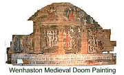
After arriving in the village Mr Naunton joined the Wenhaston Commons Group, which cares for local heathland and commons to contribute to the protection of the local environment. It was through this group that the idea for a village map for the Millennium emerged. In early-1997 the group asked Mr Naunton to lead a project to produce a map which would arouse interest in, and promote concern for, the village and its landscape. He accepted the task without, at that stage, any clear idea of how the map might look. For inspiration, he drew on historical maps with which he was familiar — John Walker's 16th Century Estate Maps and the 18th Century Chapman and Andre map of Essex. Other specific influences were the fact that Wenhaston, as 'Wenadestuna' had been surveyed and recorded in the Domesday Book and a medieval 'Doom' painting. This painting - parts of which are represented on the map hangs in the local Parish Church and portrays the judgement on peoples' lives. The aims of the project, reflecting these two influences, were to record the land, buildings and general environment of the village, and to represent what life was like in the village in AD2000.
What is remarkable about the map is that it achieves these aims completely. It shows what the area is like - to the detail of hedgerows along each lane - and gives a very good indication of what it is like to live there. Local clubs and organisations are represented, as are crops growing in the surrounding fields and even details of water and electricity supply, sewage systems and refuse collection are included! All this in a cartographically accurate, and beautifully artistic way. The accompanying extracts (not reproduced here as the whole map is available) illustrate the detail of the map and the variety of subject matter represented.
The map was compiled on twenty-four base map sheets, which were based on 3x enlargements of OS 1:2,500 maps of the area (working scale of 1:833). On these were plotted the corner points of every building and the extent of each building's plot frontage, to serve as a guide for original drawings of the properties. The survey team then drew the front elevations of the buildings to create the original 'survey drawings'. A photographic survey was also carried out, in which all properties were photographed to give an indication of their materials, textures and colours, for the final drawings. All roads and lanes were also photographed to allow true representation of their character, and aerial photography of the parish was purchased as the basis for accurately drawing the surrounding landscape. The team also carried out considerable research into village life neighbourhood watch with an added dimension! Individually commissioned photographs were used to create the special interest vignettes representing village personalities, events, and specific places of interest. When assembled, the base map measured 3 metres square - this was put on display in the village at periodic exhibitions about the project.
Each of the twenty-four sections were individually checked and updated in the field and were fair-drawn onto the 1:833 base maps, largely by Mr Naunton and to his design, but also relying heavily on newfound artistic talents of certain members of the survey team.
Reproduction
Reproduction work was a combined effort by Bartholomew/HarperCollins
and Cosmographics, with printing by Scotprint; Costs were met by
funds raised specifically for the project, mainly from local donations,
the Heritage Lottery Fund ('Awards for All') and Suffolk Rural Action
for the Environment.
The twenty-four map sections were scanned and joined together digitally into a single graphic file, and a black and white proof output at the final scale (1:2,500). This was then hand coloured by Mr Naunton and the coloured original scanned. This again had to be scanned in sections and digitally joined to ensure the joins didn't show and that colour was consistent across the map. A cromalin proof was checked, Bartholomew/HarperCollins carried out the final corrections, and 1,500 copies of the final map were printed.
Presentation
The finished map was presented to the chairman of the Parish Council
in October 2000 and copies were given to all residents of the village.
A copy is on permanent display in the village hall and one is also
shortly to be displayed permanently in the parish church near to
the inspirational 'Doom' painting.
The map, as can be imagined, received an excellent reaction from the
residents — the fact that they had all taken part, and the final
detail and extent of the record of their village that the map represented,
created great excitement. It provides a perfect geographical, historical
and social 'snapshot' of their village at the time.
As a cartographic work, I think it is excellent in the way it uses a style completely appropriate to the subject. Perhaps more maps should be designed to more closely reflect their subjects. More imaginative use of colour, materials, perspectives, type styles (the map includes fine examples of calligraphy) and textures related to the subject may help interpretation and increase a map's appeal. The Wenhaston map also illustrates the importance of having a good team with a variety of skills, all with a clear idea of the objective. Such an approach in this case has generated a unique and inspirational map.
Mick Ashworth,
December 2001
| Blythweb | Blythburgh | Bramfield | Halesworth | Southwold | Walberswick | Wangford
